SeaStorm v1.5.0.6
Requirements: 1.6 and up
Overview: SeaStorm allows you to keep track of tropical storm and hurricane activity in the Atlantic and Eastern Pacific basins. Get quick access to what you need to stay informed during hurricane season! Features include:

- Quick overview of active hurricanes, tropical storms, depressions, and other cyclones
- Per-storm advisory & discussion text from the experts at the National Hurricane Center*
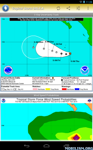
- Forecast cones (5-day uncertainty track), wind speed probability, storm surge maps (when available), and GOES Floater satellite imagery
- Background notifications of new and/or upgraded storms
- Sharing of screenshots with any app that supports it (Facebook, Twitter, etc.)
- Multiple types of regional summary maps and satellite loops to choose from (full list below)
- Tap on any map to view full screen, with pinch-to-zoom, drag, and scroll support, even during loop playback!
- Optional Forecast Model Viewer Add-On: View forecast models (also known as spaghetti models) for active systems on an interactive map complete with panning, zooming, and individual model point information when tapped. Features selectable models, start time, and run length.** (See http://www.nhc.noaa.gov/modelsummary.shtml for more information on forecast models)
Basic Maps (Atlantic & Eastern Pacific):
- Regional Overview
- Regional Outlook
Marine Maps (Atlantic):
- Sea Surface Temperature (SST) (Daily Analysis w/ Loop Playback, 7-Day Analysis, & SST Anomoly)
- Tropical Surface Analysis (Caribbean, Gulf of Mexico, & SW North Atlantic)
- Significant Wave Height Analysis
- Tropical Cyclone Danger (Mariners' 1-2-3 Rule)
- High Wind and Associated Seas
- Wind/Wave Forecasts (24, 36, 48, & 72 hour)
- Surface Forecasts (24, 48, & 72 hour)
- Peak Wave Period/Primary Swell Direction (48 & 72 hour)
- GFS Pressure Change Analysis
Marine Maps (Eastern Pacific):
- Sea Surface Temperature (SST) (Daily Analysis w/ Loop Playback, 7-Day Analysis, & SST Anomoly)
- Tropical Surface Analysis
- Significant Wave Height Analysis
- Tropical Cyclone Danger (Mariners' 1-2-3 Rule)
- High Wind and Associated Seas
- Wind/Wave Forecasts (24, 48, & 72 hour)
- Surface Forecasts (24, 48, & 72 hour)
- Peak Wave Period/Primary Swell Direction (48 & 72 hour)
- GFS Pressure Change Analysis
GOES Maps (Atlantic - Loop Playback Supported):
- Caribbean
- Central Atlantic
- East Atlantic
- East Coast
- Gulf of Mexico
- North Atlantic
- Northeast Atlantic
- Northwest Atlantic
- West Atlantic
- Wide View Atlantic
GOES Maps (Eastern Pacific - Loop Playback Supported):
- Central Pacific
- East Pacific
- Eastern East Pacific
- Hawaii
- Northeast Pacific
- Northwest Pacific
- West Central Pacific
- West Coast
- West Pacific
- Wide View East & Central Pacific
- Wide View West Pacific
GOES Map Types (Atlantic & Eastern Pacific):
- Visible
- Shortwave
- Water Vapor
- Infrared (AVN, Dvorak, JSL, RGB, Funktop, Rainbow)
- Selectable Lat/Long display for all maps
* Poignant Projects is not affiliated with NOAA (National Oceanic and Atmospheric Administration) or the NHC (National Hurricane Center)
** Forecast models can be CPU & memory intensive. The viewer will run on older devices, but newer devices will provide a better experience.
What's New
- Added overflow menu to maps that have multiple view options (long-press still works as usual)
- More fixes & optimizations (thanks everyone for the bug reports!)
new in 1.5:
- Caching support and intelligent data handling for improved performance and drastically reduced bandwidth consumption
- Added RBTOP Infrared support to GOES Floater map types
This app has NO advertisements
More Info:
Download Instructions:
http://adf.ly/XwEZy
Mirror:
http://ul.to/pjn1maav
Requirements: 1.6 and up
Overview: SeaStorm allows you to keep track of tropical storm and hurricane activity in the Atlantic and Eastern Pacific basins. Get quick access to what you need to stay informed during hurricane season! Features include:

- Quick overview of active hurricanes, tropical storms, depressions, and other cyclones
- Per-storm advisory & discussion text from the experts at the National Hurricane Center*
- Forecast cones (5-day uncertainty track), wind speed probability, storm surge maps (when available), and GOES Floater satellite imagery
- Background notifications of new and/or upgraded storms
- Sharing of screenshots with any app that supports it (Facebook, Twitter, etc.)
- Multiple types of regional summary maps and satellite loops to choose from (full list below)
- Tap on any map to view full screen, with pinch-to-zoom, drag, and scroll support, even during loop playback!
- Optional Forecast Model Viewer Add-On: View forecast models (also known as spaghetti models) for active systems on an interactive map complete with panning, zooming, and individual model point information when tapped. Features selectable models, start time, and run length.** (See http://www.nhc.noaa.gov/modelsummary.shtml for more information on forecast models)
Basic Maps (Atlantic & Eastern Pacific):
- Regional Overview
- Regional Outlook
Marine Maps (Atlantic):
- Sea Surface Temperature (SST) (Daily Analysis w/ Loop Playback, 7-Day Analysis, & SST Anomoly)
- Tropical Surface Analysis (Caribbean, Gulf of Mexico, & SW North Atlantic)
- Significant Wave Height Analysis
- Tropical Cyclone Danger (Mariners' 1-2-3 Rule)
- High Wind and Associated Seas
- Wind/Wave Forecasts (24, 36, 48, & 72 hour)
- Surface Forecasts (24, 48, & 72 hour)
- Peak Wave Period/Primary Swell Direction (48 & 72 hour)
- GFS Pressure Change Analysis
Marine Maps (Eastern Pacific):
- Sea Surface Temperature (SST) (Daily Analysis w/ Loop Playback, 7-Day Analysis, & SST Anomoly)
- Tropical Surface Analysis
- Significant Wave Height Analysis
- Tropical Cyclone Danger (Mariners' 1-2-3 Rule)
- High Wind and Associated Seas
- Wind/Wave Forecasts (24, 48, & 72 hour)
- Surface Forecasts (24, 48, & 72 hour)
- Peak Wave Period/Primary Swell Direction (48 & 72 hour)
- GFS Pressure Change Analysis
GOES Maps (Atlantic - Loop Playback Supported):
- Caribbean
- Central Atlantic
- East Atlantic
- East Coast
- Gulf of Mexico
- North Atlantic
- Northeast Atlantic
- Northwest Atlantic
- West Atlantic
- Wide View Atlantic
GOES Maps (Eastern Pacific - Loop Playback Supported):
- Central Pacific
- East Pacific
- Eastern East Pacific
- Hawaii
- Northeast Pacific
- Northwest Pacific
- West Central Pacific
- West Coast
- West Pacific
- Wide View East & Central Pacific
- Wide View West Pacific
GOES Map Types (Atlantic & Eastern Pacific):
- Visible
- Shortwave
- Water Vapor
- Infrared (AVN, Dvorak, JSL, RGB, Funktop, Rainbow)
- Selectable Lat/Long display for all maps
* Poignant Projects is not affiliated with NOAA (National Oceanic and Atmospheric Administration) or the NHC (National Hurricane Center)
** Forecast models can be CPU & memory intensive. The viewer will run on older devices, but newer devices will provide a better experience.
What's New
- Added overflow menu to maps that have multiple view options (long-press still works as usual)
- More fixes & optimizations (thanks everyone for the bug reports!)
new in 1.5:
- Caching support and intelligent data handling for improved performance and drastically reduced bandwidth consumption
- Added RBTOP Infrared support to GOES Floater map types
This app has NO advertisements
More Info:
Code:
https://play.google.com/store/apps/details?id=com.poignantprojects.seastorm
Download Instructions:
http://adf.ly/XwEZy
Mirror:
http://ul.to/pjn1maav
aanar — Mon Oct 21, 2013 5:17 pm